
Richard Musgrove
Dr Richard Musgrove is a zoologist and science journalist. He writes for Cosmos and Double Helix.
Knowing how much methane is leaking into the atmosphere from anthropogenic sources like oil, gas, coal and cows is critical as humans heat up the planet. Now UNSW researchers are trialling a new plane-mounted hyperspectral camera to make detection of local sources easier.
“Methane is a stronger blanketing effect than CO2, but doesn’t last as long in the atmosphere, therefore it’s a good candidate to reduce the emissions and you can have a quicker effect on global warming” Peter Mumford, Remote Sensing Scientist at the School of Aviation, UNSW, told Cosmos.
Global Warming Potential (GWP) is measured in relation to carbon dioxide. A GWP of 28 means that emitting on tonne of methane into the atmosphere is the same as emitting 28 tonnes of CO2.
A notoriously potent greenhouse gas, methane has a global warming potential of around 28 times that of CO2, if measured on a 100-year time scale and 80-times if that scale is 20 years, Hydrogeologist Professor Bryce Kelly, of UNSW, told Cosmos.
Incidental methane leakage from industry, called fugitive emissions, can’t be controlled unless the sources and the scale of the problem are known. In 2023, Australia produced almost four million tonnes of methane emissions, more than many larger developed economies, including the UK and Canada.
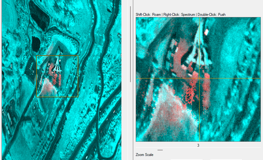
Now University of South Wales researchers are contributing to our understanding of the problem with a new hyperspectral sensor mounted on a light plane.
Mumford started testing this new piece of kit in 2024, focussing on vents he knows produced methane, in this case, the Appin underground metallurgical coal mine, in south-west Sydney, operated by Illawarra Coal.
“All underground coal mine venting is measured and reported to reasonable precision”, says Kelly. “That Appin mine is a test site for them, because it’s close to Bankstown airport, it’s a very strong source. It demonstrates that system can detect strong sources. There’s needs to be a lot of future work on weaker sources. But that is a very, very useful system for mapping the lateral extent of a plume.“

“There’s a long processing chain to extract meaningful results about the methane concentration. I do get a real time view of what I’m passing over, but it’s a false colour image, because the sensor works in the SW IR (short-wave infrared) part of the spectrum, which is outside our visual range, Mumford told Cosmos.
“Extracting methane emissions from the data that we collect is a work in progress, and very challenging. The data goes through a lot of algorithms to come up with a clean image,” he says.
“We really need to push the science, the algorithm, to create as much sensitivity as possible. But because sources are localised you know where the plume comes from. It might be a coal vent plume, landfill methane, or leaks from infrastructure pipes.
“Not like a satellite when you’re flying really, really high, and there might be multiple sources in your footprint. We fly relatively low, typically 2000m.”
Mumford makes the point of putting UNSW’s operations in context, saying that there is a whole hierarchy of platforms used for detecting methane: global scale detection with satellites; fixed-wing aircraft; drones; ground based techniques.
“We fill one area. There is a lot of interest in to verify each other’s readings, to ground-truth. Some tools will be better suited to particular sources,” he says.
“A drone or ground-based survey would suit the relatively small area of a wastewater treatment plant, whereas a large coal field, an open cut mine or a whole bunch of vents is quite well suited for fixed-wing airborne operations. Capturing large targets, its satellites of course.”
Coal mining and methane

Are you interested in the energy industry and the technology and scientific developments that power it? Then our free email newsletter Energise is for you. Click here to become a subscriber.