
Richard Musgrove
Dr Richard Musgrove is a zoologist and science journalist. He writes for Cosmos and Double Helix.
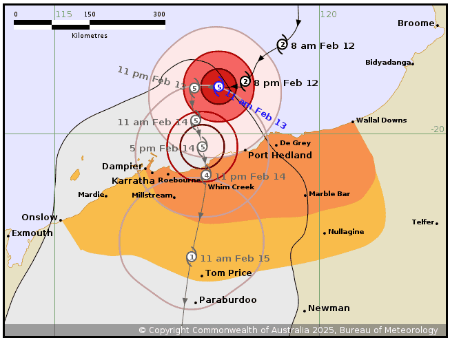
Severe Tropical Cyclone Zelia is approaching Port Hedland, Western Australia, having jumped from a Category 3 to nearly a Category 5 storm in 24 hours and is expected to make landfall sometime Friday.
“That’s a pretty impressive intensification event” says Hamish Ramsay, cyclone expert and Senior Research Scientist at CSIRO, Oceans and Atmosphere.
Cyclone intensity is based on windspeed and is broken into 5 categories, starting at less than 125km/h winds for a Cat 1 to greater than 280 km/h for a Cat 5 — from tree and farmland damage and slight swells to significant destruction with houses flattened and cars overturned.
Intensification events are becoming common, says Ramsay. “Hurricanes Milton and Helene, both underwent rapid intensification as they moved across the Gulf of Mexico before hitting Florida last year.
“It’s a trend in the last 40 years or so, and, we think that that climate change is playing a significant role in these events because of increasing sea surface temperatures.”
How do cyclones form?
It all starts with a low pressure system, created as warm tropical ocean water heats the air above, causing it to rise. Air is dragged in from the surrounds, and if the budding system is withing 500km of the equator, the force of the earth’s spin may cause the mass to start rotating — and a cyclone is born. The storm grows in intensity, as it is fed by a continuous supply of moist air, which rises and condenses, releasing heat which further warms the air, increasing its upward speed.
Cyclones spin clockwise (hurricanes spin counter-clockwise), but general movement is directed by ‘steering flow’, a 2 to 10km deep layer of atmospheric winds from a specific direction — easterly in the case of Queensland, westerly for Western Australia, both of which steer them towards land.
Then it rains. And rains
“If the steering flow is weak, the system can stall, and rainfall can be exacerbated drastically. It might just sit over the same place for many days, as it did with Cyclone Jasper in 2023, and in the US with Hurricane Harvey, which flooded Houston in 2017,” says Ramsay.
Cyclone Jasper was only a Cat 2 but was probably the wettest cyclone in Australian history, dumping 3.2 metres (m) of rain over the World-Heritage-listed Daintree National Park, and surrounding communities, in less than a week, in mid-December, 2023.
Cairns and surrounds, recorded about 2m of rain, the average annual rainfall, in six days. The Category 2 cyclone caused unprecedented flooding, and damage, overnight evacuations, and destruction of homes, water infrastructure and roads — rebuilding continues, more than a year later.

Those days of heavy rain happen because “moisture is often coming in from the ocean and from the atmosphere itself, into storms that may be many hundreds of kilometres inland,” says Ramsay.
A wetter, more intense future for the Tropics
This scale of event is set to continue.
“With global warming, there is a very strong trend towards heavy rainfall. A warmer atmosphere holds more moisture — 7% more water vapour per degree Celsius”, says Ramsay. “And if cyclones become more intense, their wind speeds increase, resulting in stronger updrafts within the core of the storm, producing more rainfall.”
The probability of heavy rain near Cairns has increased by 50% since the year 2000, writes Professor Kerry Emanuel of the Massachusetts Institute of Technology, and is likely to double by the end of this century, and triple by the end of the 21st century. The primary causes are stronger cyclones and a moister atmosphere, he adds.
And as the world warms, Ramsey adds “rapidly intensifying cyclones, are likely to become more frequent, but also the magnitude of intensification is likely to increase.”
Sudden intensification is hard to predict, writes Emanuel, which could catch people off guard, leading to more damage, injuries, and deaths. On top of that, rising sea levels could make things riskier.
The bottom line? We need better forecasts and faster ways to help people prepare, says Emanuel.
.
Cyclone behaviour is changing